Documentation
…section contains some preliminary results that will be updated only after the end of Phase 2) Layman’s Report (pdf, 4Mb), version updated on 12/07/2018. Guidelines for end-users (pdf, 2Mb), version updated…
Read moreProbabilistic Tsunami Hazard Maps for the NEAM Region
…section contains some preliminary results that will be updated only after the end of Phase 2) Layman’s Report (pdf, 4Mb), version updated on 12/07/2018. Guidelines for end-users (pdf, 2Mb), version updated…
Read more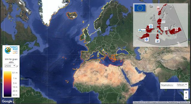
NEAM Tsunami Hazard Model 2018 (NEAMTHM18): online data of the Probabilistic Tsunami Hazard Model for the NEAM Region from the TSUMAPS-NEAM project…
Read more…curves are Probability maps for Maximum Inundation Heights (MIH) of 1, 2, 5, 10, 20 meters; Hazard maps for Average Return Periods (ARP) of 500, 1,000, 2,500, 5,000, 10,000 years….
Read more…– https://www.ipma.pt Helmholtz-Zentrum Potsdam Deutsches GeoForschungsZentrum (GFZ) – Germany –http://www.gfz-potsdam.de/ Orta Dogu Teknik Universitesi (METU) – Turkey – http://www.metu.edu.tr Universitat de Barcelona (UB) – Spain – http://www.unibarcelona.com National Observatory of Athens…
Read more
…Model. In particular, the ‘community’ seismic source model will be implemented for all the relevant seismic regions as follows. All the alternative source model implementations will be weighted according to their credibility….
Read more
Date and location: 29 June – 01 July, 2016; Room Europe Direct, Cultural Center of the Athens Municipality, Akadimias Ave. 50, Athens, Greece. Hotel recommendations can be downloaded here. Organizers; Gerassimos Papadopoulos…
Read more
…metrics we would optimally like to communicate to the Commission and other users 10.45-11.00 Coffee break Block II: 11.00-12.30 Computational aspects: · For each hazard metric discuss the needed computational…
Read more